Exhibiting the Invisible: Participatory Photo Mapping in Puerto Barrios, Guatemala
May 27, 2025
“Draw me a map of the city of Puerto Barrios.” A curved brown line cuts across the white paper, curling into a looping spiral with blue lettering spidering along its edges naming banks, hospitals, etc. This line representing the city emerges from the northern left corner, where a row of Guatemalan flags mark the communities where these Maya Indigenous participant mapmakers reside.
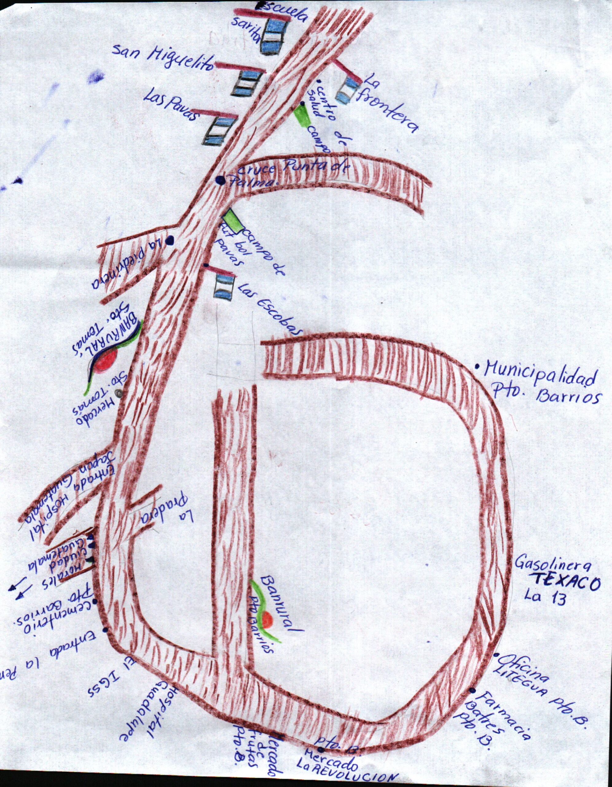
Authored by a Q’eqchi’ woman collaborator, this local map clashes with the rigid grid representations of the American-style streets and buildings depicted on official state and Google maps of the Caribbean port city of Puerto Barrios. The northern and eastern city edges meanwhile are left blank, marked as ‘nature reserves’ or simply unremarkable, uninhabited space.
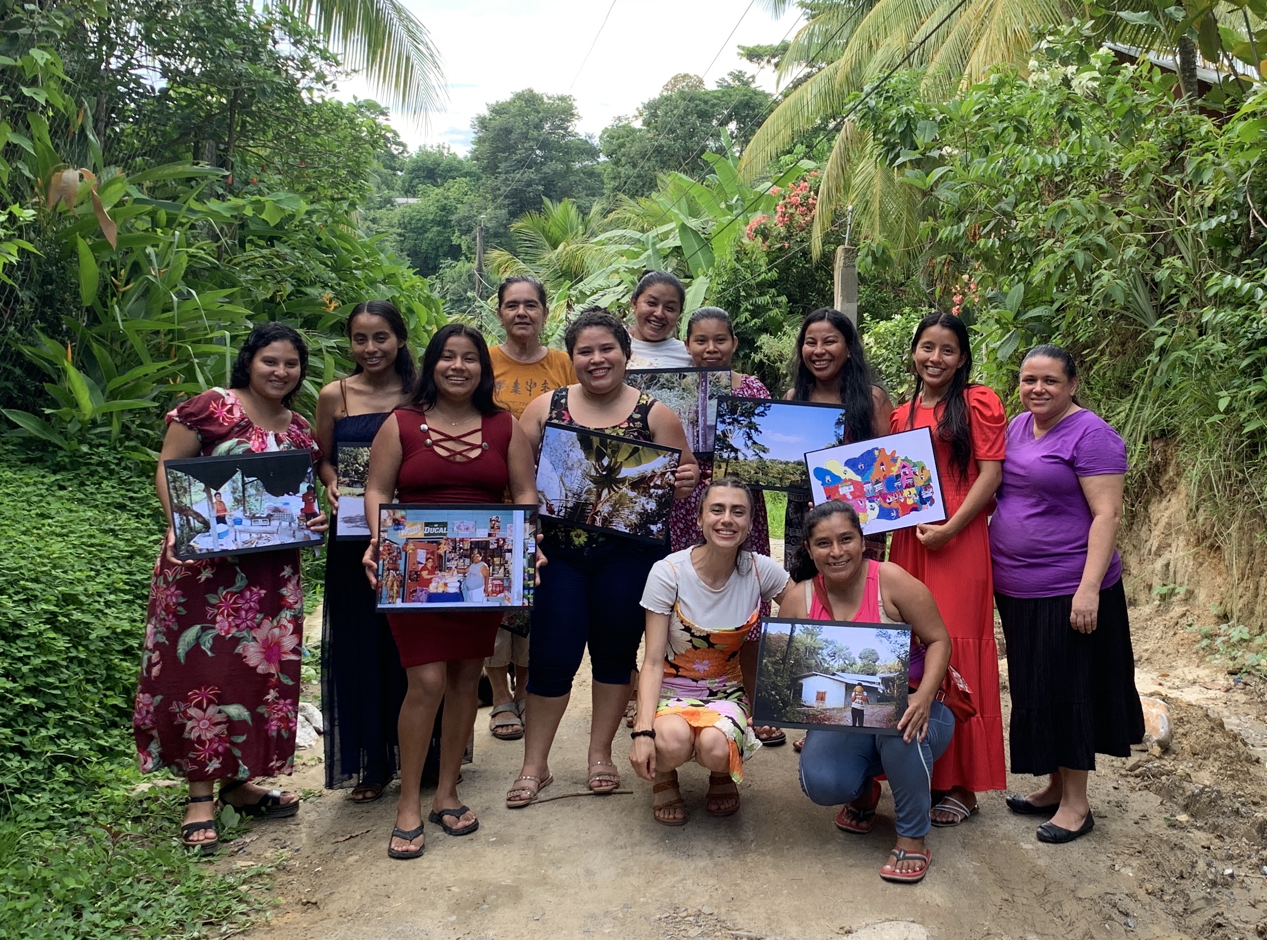
With the support of the ERI/PS2 Summer Fellowship, I organized a two-week exhibition of these maps/photographs in the Puerto Barrios library and the Sarita community center. The forty prints included in the exhibition were selected by women participants and emerged from the collaborative research I organized as part of my dissertation, in which women groups from two communities met weekly to discuss and analyze their invisible, “ungeographic” status within the city (McKittrick 2006). Beginning from the basis of mapmaking as a storytelling device, that is “as much about the narratives that are highlighted as it is about those that are veiled” (Campos-Delgado 2017), participants utilized cartography/photography to visually and textually represent their local understanding of urban space. The resultant “counter-maps” and photos included in the exhibition explore the daily challenges women face due to their erasure from urban politics while also present an alternative view of the important, and inhabited, space in the city.
The exhibition challenged understandings of these women as invisible and/or abstract photographable subjects, mainly by tourists seeking to capture an authentic ‘ethnic’ moment and/or NGOs representing poverty. It centered on the participants as key knowledge producers (Perry and Rappaport 2014), in that they were mapmakers, photographers, and curators, selecting what would be included in the exhibition. The exhibition firmly countered the invisibility of these communities and was visited by elementary schools, universities, and urban residents. It was viewed digitally by hundreds more, broadcast by the participants themselves on Facebook Live. As one participant stated on her Facebook story of a photo of her pointing to her map: “That right, look at my art. I never thought I would be able to [display it in the city library] but look now!”
Author
Lilianna Quiroa-Crowell
PS2 Public Research Fellow
Lilianna Quiroa-Crowell is a PhD candidate in Cultural Anthropology, studying the spatial experience of urban Indigenous Q’eqchi’ women in the Caribbean banana port city of Puerto Barrios, Guatemala. Her dissertation explores how the organizing and unique spatial epistemologies of these erased women, residing on the invisible urban edges, have unsettling effects on the larger exploitative power dynamics and spatial arrangements that structure daily city life. Her methodology includes participatory photomapping, in which groups of local women drew maps and took photos of their communities, culminating in a public exhibition of these “forgotten spaces” from a local perspective.
